What is mappeo.net?
It's a gmaps-youtube mashup experiment developed by fws software.
With mappeo you can geo-search for youtube videos and filter the results based on specific keywords.
mappeo.net
Blogged with Flock
It's a gmaps-youtube mashup experiment developed by fws software.
With mappeo you can geo-search for youtube videos and filter the results based on specific keywords.
Blogged with Flock
Many public-minded groups and individuals are using Google Earth to bring a valuable geographic context to their stories. These examples will show you what others have done with Earth, and hopefully get some ideas flowing for what you might be able to do yourself.
If you'd like to have your content considered for inclusion in this showcase, you can submit your KML or KMZ file here.
| Current Affairs Current affairs, public safety and disaster relief. Explore KMLs | Education & Culture Education, culture, arts and the humanities. Explore KMLs | |
| Environment & Science Environment, climate change, science and technology. Explore KMLs | Global Development Global development, microfinance, community improvement and philanthropy. Explore KMLs | |
| Public Health Health, disease and medical research. Explore KMLs | Social Services Employment services, housing & shelter and youth development. Explore KMLs |
Blogged with Flock
What's HeyWhatsThat?
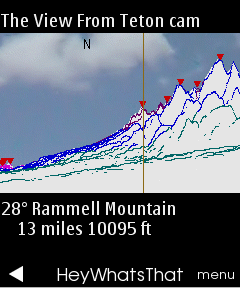
You're on top of a mountain or pulled over at a scenic overlook. You see distant summits. What are they? HeyWhatsThat provides panoramic sketches and the names of visible peaks. You can browse panoramas that someone else has requested and generate your own. And you can do it via web, email and phone. Our current offerings:
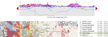
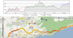 The Path Profiler allows you to create a path and generate its elevation profile. (FAQ)
  We've written Mapplets for elevation contours, path profiles, and sea level rise. (FAQ)
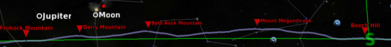
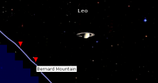 And the Cosmic Visibility page does the same inside your web browser, and gives you new insight into the Moon's phases and the Earth's seasons and what you can see on Mars. (FAQ)
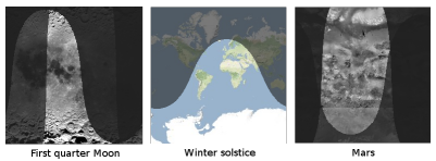
 We've got a prototype running on GPS-enabled mobile phones thanks to uLocate's WHERE technology, and it's a semifinalist in the NAVTEQ Global LBS Challenge.
Welcome to Shaded Relief of The World
You could use this interactive map in the following ways;
About ongmap.com
ONGMAP collects a vast range of information about what is at a given location and makes it easily locatable on a map of the world. For details, please read "How to use ONGMAP.COM"
ongmap.com


 indicates a country-level marker, while state, province and local markers are round
  . We currently have administrative divisions and some major cities for USA, UK, Canada, China, India, Australia, Mexico and Russia, with more coming soon. ProMED Mail: Program for Monitoring Emerging Diseases, a program of the International Society for Infectious Diseases. World Health Organization: The United Nations specialized agency for health. EuroSurveillance: Peer-reviewed European information on communicable disease surveillance and control. Published by the European Centre for Disease Prevention and Control. Google News: A commercial news aggregation service provided by Google.
 Moreover: A commercial news feed aggregation service provided by VeriSign.
Intention
The vision of Maps-For-Free is to offer relief maps and a lot of additional layers which can easily be integrated into existing google map projects. Read the Tutorial and learn how to integrate the maps and layers in your applications, Download the tiles for free or just follow the Links to see the maps in action...
Copyright Relief Maps and Layers
All relief maps and layers are licensed under a Creative Commons Attribution Share Alike 3.0 License except the labeling layer and contour layer. The labeling layer and therefore the copyright is the same as used in the satellite view with Google Maps. The contour layer is Copyright 2007 by Michael Kosowsky. All rights reserved. Used with permission. For more information visit his homepage at www.heywhatsthat.com.
Copyright Other Maps
Map data: Copyright 2007 by Europa Technologies (Street Maps)
Grafiken: Copyright 2007 by TerraMetrics, NASA (Satellite Maps)
OSM Street Maps: See www.openstreetmap.com
Impressum
Hans Braxmeir, Donausstrasse 13, 89231 Neu-Ulm, hans.braxmeier ...at... uni-ulm.de

Atlas of Our Changing Environment on Google Maps
Through illustrations, satellite images, ground photographs and powered by Google Maps, this interactive media depicts and describes humanity's past and present impact on the environment. The primary focus is on environmental status and trends over the last 30 years, in terms of both physical and human geography.

